Department of Earth Sciences
Student Research
EEOS STUDENTS PRESENT AT OCEAN SCIENCES MEETING
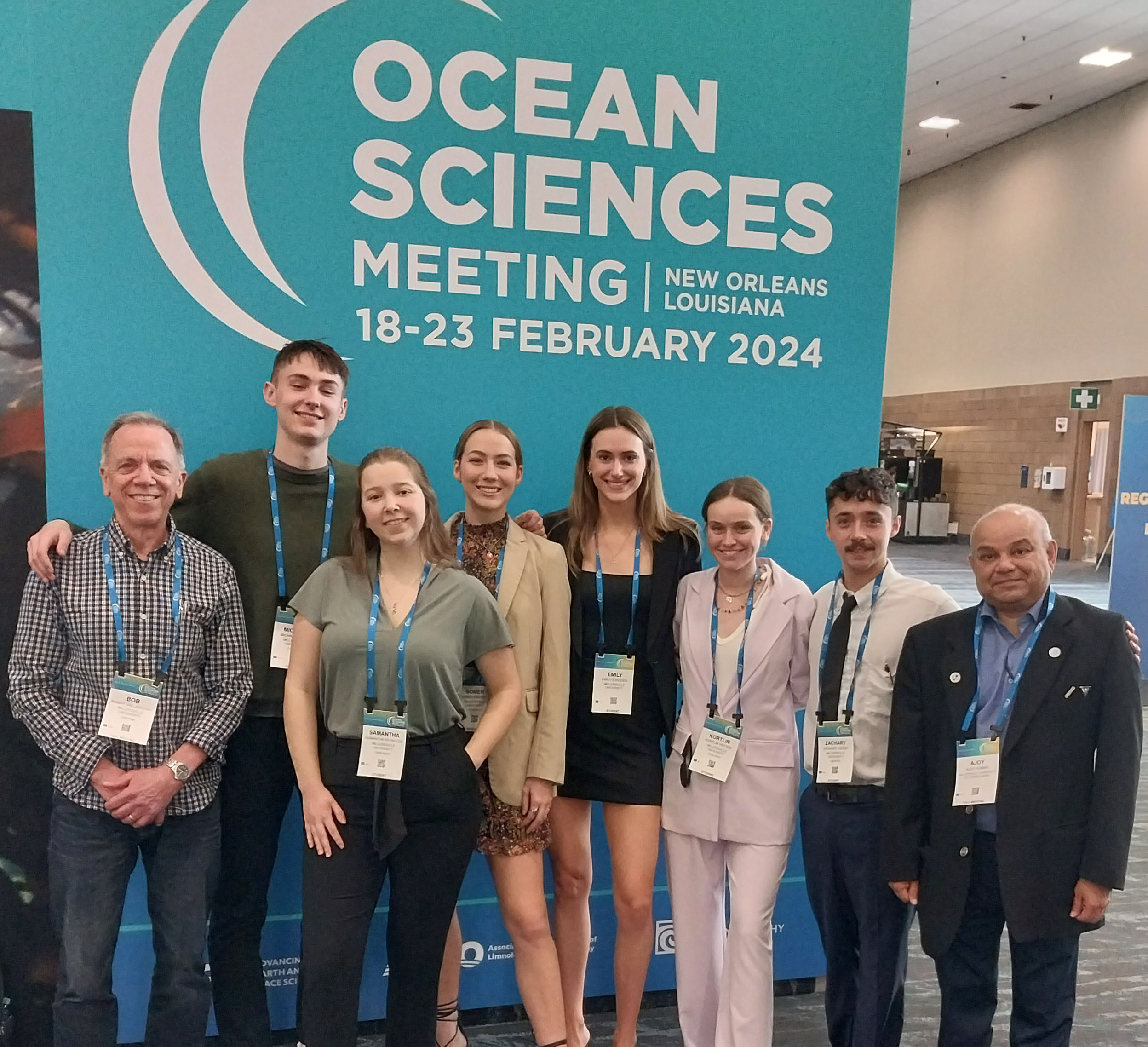
Oceanography students Mike Miller, Samantha Reynolds, Somer Barrett, Emily Stauder, Kortlin Yetter, and Zach Hersch (from left to right) presented their research at the Ocean Sciences Meeting 2024 in New Orleans in February. Professors Robert Vaillancourt (left) and Ajoy Kumar (right) accompanied them.
Title: Optical Properties of Coastal Waters: Assessing The Role of Riverine Input on the Transport of Dissolved and Particulate Carbon to the Coastal Ocean off The Delmarva Peninsula
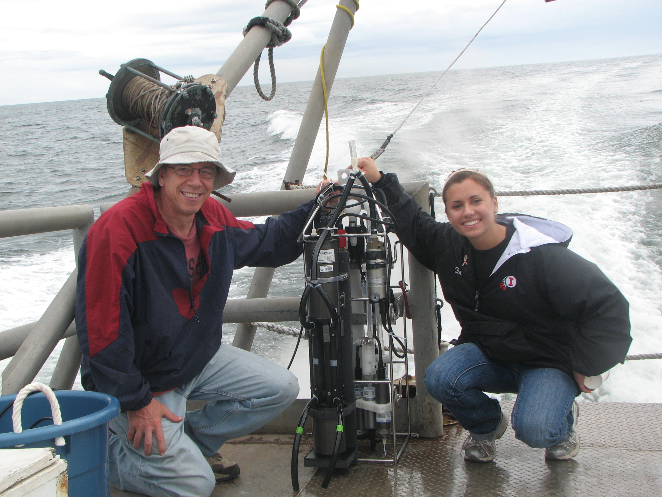
Researchers: Tia Kordell and Dr. Robert D. Vaillancourt
 Abstract: Since an important source of colored dissolved organic material (CDOM) is riverine input to the coastal ocean, the concentration of CDOM typically displays an inverse relationship to salinity. Particulate matter can be transported from rivers too, or also formed in-situ in ocean water by biological processes. CDOM and particles effectively attenuate a beam of light, making optical measurements a useful means of determining the presence of these materials. We present observations of in-water optics using a WET Labs' long-tube absorption meter (AC-9), along a cross-shelf transect from the Delmarva Peninsula seaward to the 30-meter isobath. Our objective was to relate the presence of dissolved and particulate light attenuation to the hydrographic and bio-optical properties of the water column, in order to infer their sources and origins. This project is significant in analyzing the transport of organic carbon from the land to the ocean, and to provide a deeper understanding of the ocean's carbon cycle.
Duration: Fall 2011
Caption: Dr. Vaillancourt and Tia Kordell aboard the RV Parker.
Title: Ocean Surface Optical Properties and Their Relationship to the Concentration of Chlorophyll a of Phytoplankton
Researchers: Brian Ferguson and Dr. Robert D. Vaillancourt
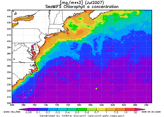 Abstract: Sunlight enters the surface ocean's upper 100 meters and interacts with seawater and the wide variety of dissolved materials and particles that are present. The color of the seawater and the color of the light that is reflected backward into space and detected by remote sensing satellites is determined by the types and amounts of these optical constituents. Shipboard data from a 2008 research cruise to the western North Atlantic Ocean aboard the research vessels RV Atlantic Explorer (BATS 226) and the RV Cape Hatteras (CH0508) were analyzed for correlations between the attenuation coefficient for blue light (K490) and for radiation across the visible band (l = 400- 700 nm, i.e., Photosynthetically Available Radiation, KPAR) and the chlorophyll a concentration (C). Correlations were observed when data were averaged and integrated over the depth of the ocean's productive layer as well as for when data from each sample depth were treated as discrete. The observed relationships fit power-law functions and were similar to published reports of attenuation and chlorophyll relationships for wide expanses of the world ocean. The study has implications for remote sensing algorithms that attempt to quantify the ocean's surface biological productivity using measurements of the quantity and spectral characteristics of sunlight reflected in the backward direction.
Duration: Fall 2012
Caption: Satellite remote sensing image of Chl a in western North Atlantic Ocean.
Title: Comparison of Ocean Chlorophyll a concentrations Determined by Satellite Remote Sensing and Shipboard Analysis in the Western North Atlantic Ocean
Researchers: Eric Weiss and Dr. Robert D. Vaillancourt
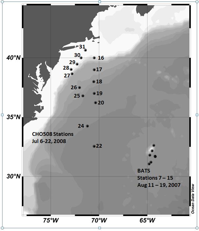 Abstract: The measure of the amount of phytoplankton biomass present in the ocean is the chlorophyll a (Chl a), a photosynthetic pigment present in all photosynthetic organisms, and aph, the absorption coefficient of phytoplankton. Several satellite sensors have been developed over the past 40 years to measure the phytoplankton biomass in the surface ocean. The objective of this project is to compare shipboard data for Chl a and aph for phytoplankton collected in the western North Atlantic Ocean during the project ON DEQUE (Optical and Nutrient Dependence of Quantum Efficiency), to the same parameter measured by satellite sensors at the same location and at the same time. Satellite-derived Chl a and aph data were averaged over a 4 km x 4 km box surrounding each shipboard data collection location for an eight-day period bracketing the day of station occupation. Strong correlations were found for matchups of shipboard Chl a and satellite Chl a (Chlsat) when the Chl a concentrations were summed over the first optical depth (r^2= 0.64) than when the entire euphotic zone was sampled (r2 = 0.55). Strong correlations were found in matchups of shipboard aph and satellite aph, and these correlations were similar for the first optical depth (r^2 = 0.82) and the entire euphotic zone (optical depth = 4.6; r2= 0.78). Sea-truthing studies such as this one provide important insight into the efficacy of remote sensing algorithms, and hence our ability to remotely sense the surface ocean environment.
Duration: Fall 2012
Caption: Study site for ON DEQUE project in western North Atlantic Ocean.
Title: Projecting the Impacts of Climate Change and Identifying Adaptation Options at Wallops Island, Virginia.
Researchers: Matthias Miziorko, Nate Murry, Dr. Ajoy Kumar
Abstract: This project will use existing data including remote Light Detection And Ranging (LiDAR) data to map the current distributions of important habitats, detail the likely areas of greatest impact from rising sea levels, quantify the rate of habitat change, and identify areas that may become important wetlands as the coastal systems attempt to migrate inland. The data collected includes aerial LiDAR cloud points and in situ location corresponding to the cloud points. These are essential precursors to the effective management of the Chincoteague National Wildlife Refuge site under climate change. The project will also develop management strategies to lessen the impact of climate changes and natural disasters.
Duration: Fall 2010 - Present
Title: Coastal Ocean Circulation of Wallops Island, Virginia
Researchers: Virginia Maroulis and Dr. Ajoy Kumar
Abstract: The Wallops Island region is dynamic environment consisting of a Barrier Island Ecosystem complete with a classical Tidal Inlet. The dynamic salt marshes are an ideal environment for many species of plants and animals native to the region. The proximity to the Marine Science Consortium (MSC) has allowed a collection of large amount of oceanographic data from this region. What is lacking however is a coherent scientific analysis of this data set to bring out the unique circulation features of this region. Millersville University is a senior full member of the MSC and it is imperative that Ocean Sciences and Coastal Studies (OSCS) students are exposed to modern data analysis and scientific interpretation of the dynamic environment at Wallops Island.
In this study, Virginia will use the data collected from different cruises, assemble them together and analyze the data. She will later combine the results of her analysis with satellite data of temperature, color and surface currents of the region. This exercise will help Virginia to utilize the theory and principles learnt from OSCS courses to then be able to apply these concepts to real oceanographic environments. Eventually, it is expected that this experience will not only enrich her knowledge and skills in oceanographic but also to help her to find a suitable job in the field after graduation.
Duration: Spring 2011 - Present
Title: CODAR observed spatial resolution of tidal dynamics along the lower Delmarva Peninsula.
Researchers: Alex Davies, Dr. John Moisan, Dr. Ajoy Kumar
Abstract: A long term coastal ocean observational network is being developed in order to improve our understanding of the dynamics of coastal environments. One aspect of this observing system is the deployment of High Frequency Radar (primarily CODAR) systems that can measure surface coastal ocean currents on hourly time scales up to 200 km off shore and at spatial resolutions of about 10 km. Tidal harmonics were computed using a year of observations from 3 CODAR systems deployed along the Delaware, Maryland, and Virginia coast under support from the NOAA Integrated Ocean Observing System (IOOS). The resulting tidal current estimates were then removed from the raw HF Radar current estimates to render a composite of the mean surface circulation pattern for this coastal ocean region. Tidal currents in this region account for up to 60% of the total current variability, particularly at the mouth of the Chesapeake Bay. Using the tidal harmonics, a year's worth of daily progressive vector diagrams were analyzed in order to ascertain the level of 'jitter' that one could expect from obtaining hourly images from a geostationary hyperspectral ocean color satellite.
Duration: Fall 2009 - Spring 2010
Title: A simple technique to remove tidal influence from ADCP measurements
Researchers: Justin Gilchrist, Alex Davies, Dr. Ajoy Kumar
Abstract: Acoustic Doppler Current Profiler (ADCP) measured current velocities close to the coast are strongly influenced by the local tides and there lacks a simplistic method of removing this influence from vessel mounted observations. In this study, we demonstrate a new simple technique that allows us to de-tide the observed ADCP velocities. The technique is based on simple vector differencing method. The first step in the process is to produce tidal velocities of the region using the ROMS model. In the next step, we remove the tidal velocities from the ADCP data using vector differencing at a number of points along the ships track. An extensive error analysis will be carried out to assess the validity of our de-tiding methods. Two sets of points will be used in this study. The first set will contain points that lie inside the model domain and the second set of points that lie on the model boundary. In this way, we can determine the effect of the model boundaries on the above technique. Results will determine the feasibility and accuracy of the technique.
Duration: Spring 2009 - Spring 2011 (Justin) & Spring 2009 - Spring 2011 (Alex)
Title: . Monitoring the coastal ocean environment for Harmful Algal blooms
Researchers: Brian McCormick and Katie Hoyt
Abstract: Karenia Brevis is a dinoflagellate that causes a Harmful Algal Bloom (HAB) off the coast of Florida. Karenia causes Neurotoxic Shellfish poisoning (NSP). The goal of this project is to identify the conditions in which the bloom is most likely to occur. We will use both satellite ocean color and temperature parameters along with numerical model outputs to detect the blooms and identify conditions necessary for the onset of the blooms.
Duration: Fall 2007-Spring 2009
Faculty Research
- Coastal Observations off Delmarva.
- Interdisciplinary Studies in the Arabian Sea and Bay of Bengal.
- Projecting the Impacts of Climate Change and Identifying Adaptation Options at Wallops Island, Virginia.
- Sea-Surface Temperature Retrieval Algorithms.
- Photosynthesis and carbon dioxide uptake in the Southern Ocean: The Southern Ocean Gas Exchange Experiment (SO GasEX).
- Wallops Island Science Training Program for Emergency Certified Teachers.
- Weather in a Tank.
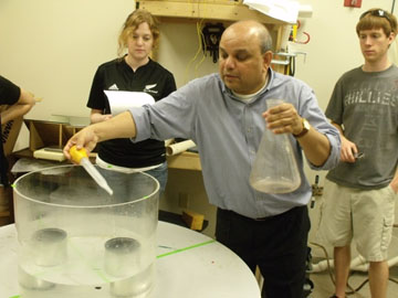
Photo: Dr. Kumar demonstrating an experiment using the rotating tank in the University's earth science building.